Autumn Storm Brings Heavy Rain and Flooding Concerns to Los Angeles and Southern California
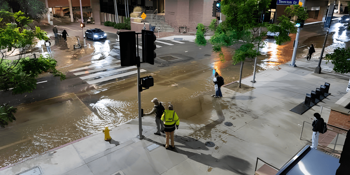
Rain moved across Southern California as forecasters warned of downpours, possible thunderstorms and localized flooding through Thursday.
A strong autumn storm moved into Southern California on October 21, bringing rain to communities across the region and prompting warnings about heavy downpours, possible thunderstorms and localized flooding. The system was expected to continue affecting the area into Thursday, with the heaviest rainfall forecast for parts of Los Angeles County and surrounding communities.
The storm moved south along the California coast after bringing significant rainfall to areas farther north. Santa Barbara County received about an inch of rain early Wednesday, according to the National Weather Service, before the system advanced toward Ventura and Los Angeles counties.
Forecasters warned that rainfall rates could become intense in localized areas, particularly where thunderstorms developed. The changing conditions raised concerns about flooded roads, reduced visibility and runoff in places where water could accumulate quickly.
Although autumn storms are a normal part of California's seasonal weather, their impacts can vary significantly depending on rainfall intensity, terrain and the condition of local drainage systems.
Rainfall Expected to Intensify Overnight
The forecast called for a period of heavier rain from Wednesday afternoon into Thursday morning. Los Angeles County was expected to receive around 1.5 inches of rain in many areas, while locations affected by terrain-enhanced rainfall or thunderstorms could receive between two and three inches.
Those amounts are not uniform forecasts for every neighborhood. Rainfall can vary sharply across Southern California because of the region's mountains, valleys, coastal areas and localized storm development.
Forecasters estimated a 30% to 40% chance of heavier downpours during Wednesday night in parts of the region. Some rainfall rates could reach approximately three-quarters of an inch per hour, increasing the potential for water to collect rapidly on streets and in low-lying areas.
The timing of the heaviest rain is important for commuters and residents. Downpours during evening travel can reduce visibility, make roads slippery and create sudden pools of water in locations that may not normally experience flooding.
Local authorities and residents were advised to pay attention to updated forecasts and warnings as the storm progressed. A change in the position or strength of a rain band can significantly affect which communities receive the greatest rainfall.
Why Southern California Can Flood Quickly
Southern California's varied landscape creates several different flood risks during heavy rain. Urban areas contain roads, parking lots and other paved surfaces that limit how much water can soak into the ground. When rainfall becomes intense, runoff can move toward storm drains faster than the system can carry it away.
Mountainous and hilly areas face a different set of concerns. Water can flow rapidly down slopes and into channels, while steep terrain may concentrate runoff into narrow drainage areas. Communities near burn scars can face additional hazards because fire can alter soil conditions and reduce the landscape's ability to absorb rainfall.
The extent of these risks depends on local conditions. Not every storm produces flooding, and not every neighborhood faces the same level of exposure. However, short periods of intense rain can create dangerous conditions even when total rainfall across the wider region appears moderate.
Drivers are particularly vulnerable when roads become flooded. Water can hide potholes, debris or damage to the pavement, and the depth may be difficult to judge from a vehicle. Officials generally advise motorists not to drive through flooded roadways.
Thunderstorms Add Uncertainty
The possibility of isolated thunderstorms increased uncertainty around the storm's local impacts. Thunderstorms can produce rainfall at higher rates than surrounding areas, creating sharp differences in accumulation over relatively short distances.
Lightning and strong localized winds can also accompany thunderstorms. These conditions can affect outdoor activities, construction work and transportation, particularly when storms develop quickly.
The storm was expected to bring cooler conditions to the region through Thursday. The arrival of rain and lower temperatures marked a change from the warmer, drier weather often associated with Southern California earlier in the season.
However, a cooler day does not necessarily indicate that the most hazardous conditions have passed. Residents need to follow the timing of local warnings rather than relying only on temperature or the appearance of the sky.
Effects on Commuters and Local Businesses
Heavy rainfall can affect daily life across Los Angeles and nearby communities even when widespread damage does not occur. Commuters may face slower journeys, transit delays and reduced visibility. Businesses with outdoor operations may need to adjust schedules, while delivery services can encounter longer travel times.
Construction sites and event organizers may also need to account for wet conditions. Rain can affect ground stability, equipment use and the safety of outdoor work. Businesses operating in areas with a history of flooding may need to protect supplies and equipment from water intrusion.
For local residents, practical precautions include allowing extra time for travel, avoiding flooded roads and checking whether local authorities have issued closures or warnings. People in areas vulnerable to runoff should also remain alert to rapidly changing conditions during periods of intense rainfall.
The storm's impact on individual neighborhoods will depend on rainfall totals, drainage capacity and local geography. Forecasts can identify elevated risk, but they cannot determine in advance exactly where every flooded street or runoff problem will occur.
A Seasonal Reminder for the Region
The October storm highlights the importance of preparing for heavy rain even in a region better known for dry weather and prolonged sunshine. Southern California can experience substantial rainfall from autumn through winter, and the first stronger systems of the season may arrive after months of relatively dry conditions.
Communities with efficient drainage systems and well-maintained infrastructure may manage some rainfall events without major disruption, but intense downpours can still overwhelm localized areas. Emergency preparedness and accurate forecasting remain important tools for reducing the risks.
As the system moves through the region, the key concerns are the timing of the heaviest rain, the possibility of thunderstorms and the potential for localized flooding. Conditions may improve after the storm passes, but residents should continue to rely on updated local forecasts before assuming that travel and outdoor activities have returned to normal.
For Los Angeles and surrounding communities, the storm serves as a reminder that weather hazards are not limited to extreme heat, wildfires or major winter storms. A few hours of intense rainfall can also disrupt transportation, challenge infrastructure and create risks that require careful attention from residents, businesses and local officials.

LA News Daily Contributor
This article features partner, contributor, or branded content from a third party. Members of the LA News Daily editorial staff were not involved in the creation of this content. All views and opinions are those of the contributor alone.