Hurricane Marie Brings Unusual September Weather Threat to Southern California Beaches
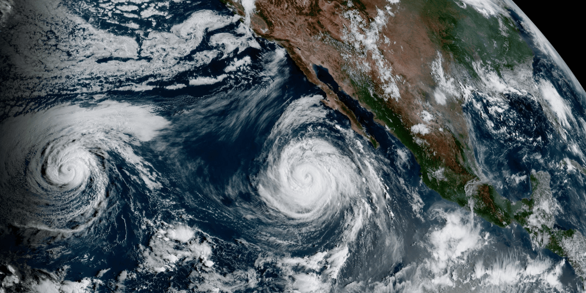
Southern California entered the Labor Day weekend under an unusual weather setup Friday as Hurricane Marie remained well offshore while sending tropical moisture and a powerful south swell toward Los Angeles and surrounding coastal communities.
The National Weather Service office serving Los Angeles and Oxnard said Marie was expected to remain well offshore, but its moisture and ocean effects were still expected to influence the region through the holiday weekend and into early the following week.
Dangerous Surf Becomes the Main Local Concern
The most immediate concern for Los Angeles-area residents and visitors was not a direct hurricane landfall but the ocean conditions produced by the distant storm.
The National Weather Service forecast a south swell of approximately 5 to 8 feet on exposed south-facing beaches, with some locations potentially experiencing larger waves. High Surf Advisories remained in effect for Los Angeles and Ventura counties.
The agency warned of potentially dangerous rip currents and large waves during a holiday weekend when beaches were expected to be crowded.
The combination was particularly significant because Marie was not expected to strike Southern California directly. Instead, the storm’s influence was being transmitted through the Pacific Ocean and atmospheric moisture, creating hazards despite the storm center remaining far offshore.
Rain Could Follow the Coastal Swell
Rain was also expected to become more likely as the weekend progressed.
The National Weather Service said Los Angeles County had a 50% to 80% chance of rain during portions of Sunday, while chances were lower in Ventura and Santa Barbara counties. Some thunderstorms were also possible, particularly in Los Angeles County.
Forecast rainfall totals were expected to remain relatively light for most population centers, with approximately a quarter-inch or less expected in many locations.
That did not eliminate potential localized problems. Forecasters noted that even relatively light rain could make roads slick because of accumulated oils and other surface materials following the dry summer period.
A Rare Weather Pattern for Early September
The weather setup was notable because tropical moisture was interacting with a persistent upper-level trough near the West Coast.
The National Weather Service described the pattern as unusual for Southern California in early September. Moisture from Marie was expected to move northward while atmospheric conditions supported the possibility of showers and thunderstorms.
That combination meant the region could experience conditions more commonly associated with tropical systems while the hurricane itself remained hundreds of miles offshore.
The storm was located well southwest of the Baja California peninsula on Friday morning. The National Hurricane Center reported maximum sustained winds of about 100 mph and said Marie was moving west-northwest away from land. No coastal watches or warnings were in effect.
Holiday Weekend Raises Exposure
The timing of Marie’s influence was particularly important for Southern California.
The Labor Day weekend traditionally brings large numbers of people to beaches, coastal parks and recreational areas. The National Weather Service specifically highlighted the expected crowds when maintaining its high-surf warnings.
The risk therefore came from exposure to ocean conditions rather than a direct hurricane threat.
Higher tides were also expected later in the weekend and into early the following week. The combination of larger waves, stronger currents and elevated tides increased the potential for dangerous conditions around exposed beaches and vulnerable coastal areas.
What the Local Outlook Means
For Los Angeles and Southern California, Marie represented a reminder that tropical systems can affect the region without making landfall.
The storm’s direct wind threat to Los Angeles remained limited because its projected track kept it offshore. The more immediate local effects were expected to involve surf, rip currents, moisture and periods of rain.
The National Weather Service’s forecast also emphasized uncertainty later in the period as atmospheric patterns could influence how much tropical moisture reached Southern California.
The significance of Friday’s forecast was therefore less about a hurricane approaching Los Angeles and more about an unusual coastal weather event arriving during one of the region’s busiest beach weekends.
For residents and visitors, the distinction was important: Southern California was not facing a direct hurricane strike, but the distant storm was still capable of producing dangerous local conditions along the coast.
The weekend outlook placed beaches, surf conditions and changing weather at the center of Southern California’s local-event calendar, with Marie adding an unusual meteorological dimension to the holiday period.

LA News Daily Contributor
This article features partner, contributor, or branded content from a third party. Members of the LA News Daily editorial staff were not involved in the creation of this content. All views and opinions are those of the contributor alone.